Part D
Correlating Maps & Images
So, now that you know how to read a topographic map, you'll never get lost, right? Well, probably not, but you'll certainly be better equipped to navigate from place to place. When out in the field, it's not good enough to think that you won't get lost just because you can read a topo map. The real skill in finding your way around without getting lost lies in the ability to accurately compare and correlate both types of information. This is exactly what you would be doing for real, out on a hike.
|
|
|
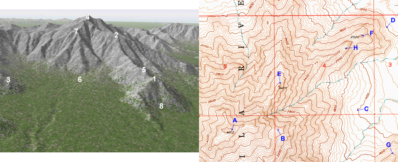
Figure 2-21. The Sierra Estrella is a NW-trending mountain range southwest of Phoenix, Arizona. Part of the Sierra Estrellas is represented by a 3D model generated from digital elevation data (left). |
Figure 2-21 above is a labeled 3D model and topo map of a portion of the Sierra Estrella Mountains located southwest of Phoenix. Compare the 3D model image to the topographic map. Note the more distinctive features in the 3D model, like prominent peaks, ridgelines, etc. and try to find them on the topo map. Once you have a few matches, you can then align all of the other locations fairly easily. With a real map, you can rotate the map so that all of the locations align with the landscape that you see.
A few additional notes:
1) Topographic maps are typically oriented with North towards the top of the page, whereas the 3D model views likely show a different perspective (life would be pretty strange if all our pictures were pointed only toward the North!).
2) You can commonly see a lot more of the surrounding area in 3D model image as the topo map typically covers a smaller area than the 3D model.
Use the Sierra Estrella 3D model and topo graphic map as a reference for questions D41 through D50. Click HERE to see a PDF version of this map.
![]()
![]()
![]()
![]()
![]()
![]()
![]()
![]()
![]()
![]()
After finishing this lesson, complete the form below:
