Part D
Getting Oriented
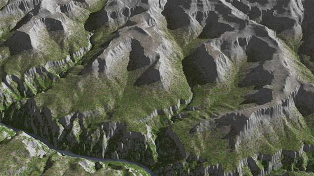
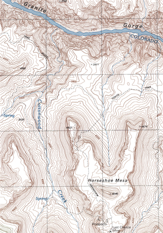
So, now that you know how to read a topographic map, you'll never get lost, right? Well, probably not, but you'll certainly be better equipped to navigate from place to place. When out in the field, it's not good enough to think that you won't get lost just because you can read a topo map. The real skill in finding your way around without getting lost lies in the ability to accurately compare and correlate both types of information. Look at Figure 2-24 and compare the color 3D model image to the topographic map. This is exactly what you would be doing for real, out on a hike.
|
|
|
|
Figure 2-24. A 3D digital elevation model (DEM) generated from elevation data of the Horseshoe Mesa area of the Grand Canyon (left), and a topographic map for part of the area shown in the 3D model (right). Note: the topomap at right is not oriented in the same direction as the DEM. |
|
A few additional notes:
1) Topographic maps are typically oriented with North towards the top of the page, whereas the 3D model views likely show a different perspective (life would be pretty strange if all our pictures were pointed only toward the North!).
2) You can see a lot more of the surrounding area in 3D model image as the topo map typically covers a smaller area than the 3D model.
Back to Horseshoe Mesa
Quiz Me! questions D43 through D50 refer to the Horseshoe Mesa topographic map and the corresponding digital elevation model (DEM). See the links below to see a high-resolution, printable PDF versions. Smaller, lower resolution versions of the DEM and topo map are also be included with some of the questions.
|
Horseshoe Mesa DEM |
|
Horseshoe Mesa topographic map |
![]()
![]()
![]()
![]()
![]()
![]()
![]()
![]()
After finishing this lesson, complete the form below:

