Part C
Mars Exploration Rover Landing Sites
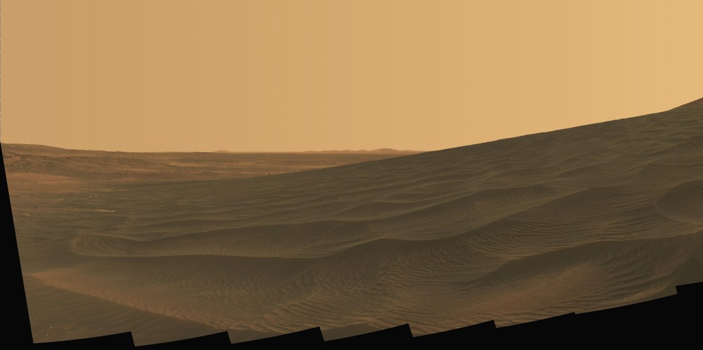
In January, 2004, the two Mars Exploration Rovers, Spirit and Opportunity, began their journey across the Martian landscape (see Figure 2-21). Many possible landing locations were considered, with attention paid to their geologic features, navigable terrain, landing safety issues, amount of sunlight, etc. Finally, two landing locations were chosen: Gusev Crater and Meridiani Planum. Both places have many interesting geologic aspects and are relatively flat for a safer landing. Gusev Crater and Meridiani Planum are also located near the Martian equator, offering the maximum amount of high-angle sunlight to power the rover batteries. We will discuss the topography and geology in more detail in a later lab, but for now, let's look at the basic topography of each area.
|
|
|
|
Figure 2-21. Rover views of the Martian landscape. At left, a photo taken by Spirit (MER-A) on January 1, 2006 from Gusev Crater, looking up a slope and across rippled sand deposits in a dark field dubbed "El Dorado" (Cornell/JPL/NASA). |
|
Gusev Crater
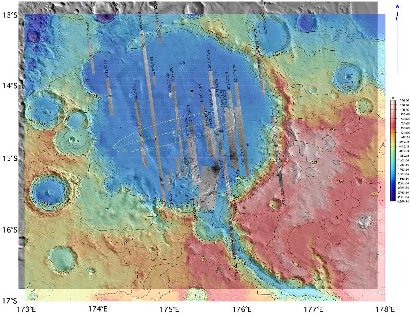
Below is a color topographic map of the landing area for the Mars Exploration Rover Spirit (Figure 2-22). Taken from the Mars Global Surveyor spacecraft, the image combines photographs taken by the Mars Orbital Camera (MOC) with elevation data from the Mars Laser Altimeter (MOLA). Geographic North is towards the top of the image, and latitude and longitude coordinates are located along the margins. Elevations are in meters above and below a reference datum (a Martian sea level, if it had one). An explanation for map elevations shows the color scheme used to describe the elevations, with red and white representing the highest elevations and blue representing the lowest. The colors are added to make it easier to interpret the elvation differences. The negative elevations (like -500) are elevations measured below the "0-meter" reference datum ("sea level"). The ellipses show the projected landing areas for each rover within Gusev Crater.
|
|
|
Figure 2-22. A color-coded topographic map of the MER-A (Spirit) landing site in the Gusev Crater area on Mars. The gray strips are terrain imaging data. |
Use the Gusev Crater topographic map to answer Quiz Me! questions C36 through C40 (see the link below to see a high-resolution, printable PDF version). Smaller, lower resolution versions of the topo map may also be included with some of the questions. Do not use the map in Figure 2-22.
|
Gusev Crater topographic map |

Meridiani Planum
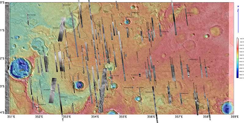
Below is a color topographic map of the landing area for the Opportunity Mars Exploration Rover (Figure 2-23). This image is very similar to the Gusev Crater map, except that the elevation scale and color schemes used to describe elevations are a little different on this image. For instance, all the elevations on this map are negative (below "sea level"), whereas the Gusev Crater map also had positive elevations.
|
|
|
Figure 2-23. A color-coded topographic map of the MER-B (Opportunity) landing site in the Meridiani Planum area on Mars. The gray strips are terrain imaging data. |
Use the Meridiani Planum topographic map to answer Quiz Me! questions C41 and C42 (see the link below to see a high-resolution, printable PDF version). Smaller, lower resolution versions of the topo map may also be included with some of the questions. Do not use the map in Figure 2-23.
Do not use the Figure 2-23 image.
|
Meridiani Planum topographic map |