Part C
Yellowstone National Park Geology
As the youngest Period of geologic time, Quaternary rocks and structures are widely exposed all across North America. Located in the Rocky Mountain region, the mantle-plume-derived Yellowstone hot-spot has created some fantastic volcanic geology and notable prehistoric eruptions. The Quaternary volcanism in the Yellowstone area occurred in three main phases. The major events of each phase were eruption of a voluminous ash-flow sheet and formation of a large collapse caldera, with lesser precaldera and postcaldera rhyolitic lava flows and marginal basaltic lavas (Christiansen and Blank, 1972). Caldera eruptions of the first phase occurred ~2.1 Ma and produced the voluminous Huckleberry Ridge Tuff (2450 cubic km). The second phase at 1.3 Ma produced the Mesa Falls Tuff (280 cubic km), most of which is not exposed within Yellowstone National Park. The last phase produced the Lava Creek Tuff (1000 cubic km) at 640 Ka. See HERE for a graphic showing the relative volumes of these caldera-forming eruptions. The three biggest eruptions occurred at a frequency of roughly one every 700,000 years, and with the hot-spot still being active, the next eruption could come at any time. Let's explore the Quaternary volcanic geology of Yellowstone National Park to learn more about this sleeping (for now) caldera supervolcano.
|
|
|
|
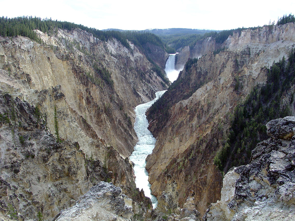
Figure 15-7. Geologic attractions of Yellowstone National Park. At left, altered rhyolitic tuff forms the Grand Canyon of the Yellowstone River in the Lower Falls area (USGS). At right, Grand Geyser of the Upper Geyser Basin (USGS). |
|

Geologic Map of Yellowstone National Park
The geology of an active continental hot spot is displayed in northwestern Wyoming at Yellowstone National Park. The Quaternary geology in this area is dominated by rhyolitic volcanics, largely represented by numerous ash flow tuff units. The scenic landscapes and localized Holocene hot spring activity and their deposits draw many visitors to the park each year.
|
|
|
|
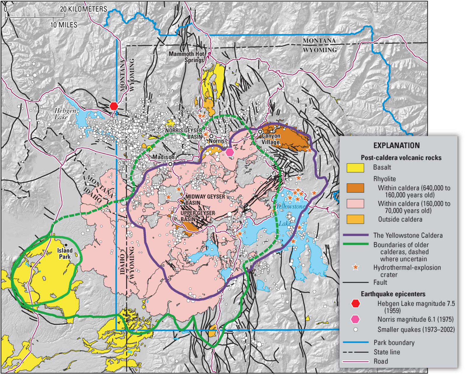
Figure 15-8. Yellowstone's active geology. A generalized geologic map of the Yellowstone area showing the location of the Yellowstone caldera (left). |
|
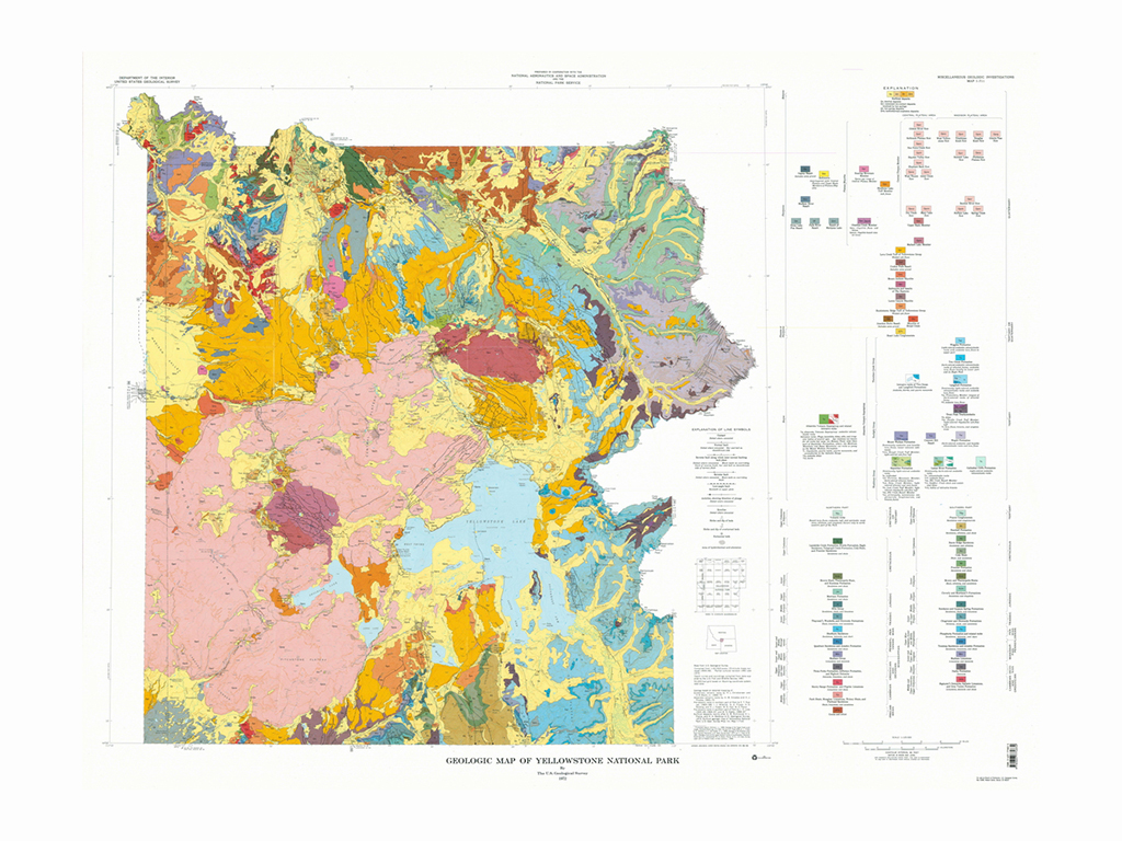
Answer Quiz Me! questions C19 through C29 using the Geologic Map of Yellowstone National Park (see the PDF link below). If necessary, refer to your rock identification charts (Igneous HERE / Metamorphic HERE / Sedimentary HERE).
|
Geologic Map of Yellowstone National Park |
A Trip to Old Faithful & Yellowstone Lake
You are visiting Yellowstone National Park and enter at the West Entrance in West Yellowstone. You want to see some of the famous geysers and hot springs, but also would like to see Yellowstone Lake.

You drive about 10 miles east along the West Entrance Road to Madison Junction.
From Madison Junction, you head south along the Grand Loop Road where it goes south through Firehole Canyon.
Continuing on the Grand Loop road to the east, you eventually come to Yellowstone Lake at West Thumb. You decide to leave the Park and turn south onto the South Entrance Road.