Part C
Late Paleozoic Geology: Appalachian Mountains & Grand Canyon
Rocks of Late Paleozoic age are exposed across North America, including in the Appalachian Mountains in the east and in the Grand Canyon region of the Southwest. The depositional environments for these rocks varied widely, and significant accumulations of plant material formed some of the world's important coal deposits.
|
|
|
|
|
Figure 11-7. Early Paleozoic geology is well exposed on both sides of North America. We will study this geology using geologic maps and an infographic. The Geologic Map of the Wyndale and Holston Valley Quadrangles, Virginia (left), the Grand Canyon Stratigraphy poster (middle), and the Geologic Map of Eastern Grand Canyon (right). |
||
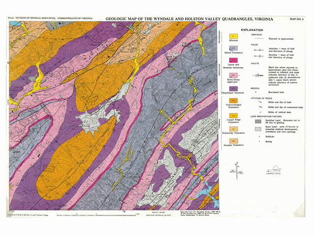
Geologic Map of the Wyndale and Holston Valley Quadrangles
Fold structures are abundant in the central Appalachian Mountains. The Paleozoic sedimentary layers in this region have been deformed into a multitude of largely parallel anticlines and synclines. These folds form the distinctive landscape of the Valley and Ridge physiographic province.
|
|
|
|
Figure 11-8. Paleozoic fold structures compose the central Appalachian Mountains of Virginia and Tennessee. At left, an aerial view of the Stony Creek syncline is located just southeast of the Wyndale and Holston Valley quadrangle. |
|


Answer Quiz Me! questions C19 through C26 using the Geologic Map of the Wyndale and Holston Valley Quadrangle (see the PDF link below). If necessary, refer to the Sedimentary Rock Identification Chart (see PDF HERE).
Explanation

Geologic Map
Cross Section A-A'
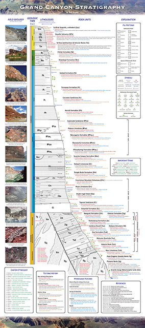
Grand Canyon Stratigraphy
Late Paleozoic rocks form the uppermost layers in the walls of the Grand Canyon and much of the surrounding plateau areas. These sedimentary layers include massive, cliff-forming units like the Mississippian Redwall Limestone. The thick Pennsylvanian-Permian Supai Group forms an alternating sequence of cliffs and slopes, whereas the Permian Hermit Formation is a distinctive reddish slope-forming unit beneath the cliffs of the Permian Coconino Sandstone. The entire section is capped by the youngest Permian layer, the Kaibab Formation, which is widely exposed across northern Arizona.
|
|
|
|
Figure 11-9. Late Paleozoic geology in the Grand Canyon as seen from the rim and the river. The view from Point Imperial of Hayden Butte, where tan Coconino Sandstone caps a sequence older red rocks (left). |
|


Answer Quiz Me! questions C27 through C38 using the Grand Canyon Stratigraphy poster (see the PDF link below). If necessary, refer to the Sedimentary Rock Identification Chart (see PDF HERE).
|
Grand Canyon Stratigraphy |
Rock Units
Rock Types
Fossils
Locations
Waterfalls & Springs
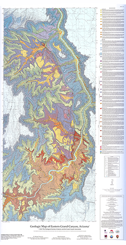
Geologic Map of Eastern Grand Canyon
Late Paleozoic rocks form the upper layers in the Grand Canyon, the North and South Rims, and much of the plateau country in all directions. These rocks are well exposed in the easternmost part of the Grand Canyo, where the Colorado River turns from its southerly course to a more westerly one. Access to the canyon in this area is afforded by only a few trails, namely the Tanner trail from the South Rim and the Nankoweap trail from the North Rim, and, of course, the Colorado River.
|
|
|
|
Figure 11-10. More Late Paleozoic geology in the Grand Canyon as seen from the rim and the river. Looking southwest from Cape Final along the North Rim towards Vishnu Temple and Freya Castle (left). |
|


Answer Quiz Me! questions C39 through C43 using the Geologic Map of Eastern Grand Canyon (see the PDF links below). If necessary, refer to the Sedimentary Rock Identification Chart (see PDF HERE).
|
Geologic Map of Eastern Grand Canyon |
|
It's a big map, so it may take a minute to load. |
Geologic Map