Part B
Late Paleozoic Paleogeography & Life Forms
As with their Early Paleozoic counterparts, Mississippian, Pennsylvanian, and Permian rocks are exposed around the world and represent diverse geologic settings. These rocks not only contain abundant marine organisms, but a wide range of land animals and plants as well.
|
|
|
|
Figure 11-4. Late Paleozoic rocks along the Bright Angel trail in the Grand Canyon. At left, a massive wall of the Permian Coconino Sandstone, representing a thick accumulation of coastal sand dunes. |
|


A Correlated History of Earth: Late Paleozoic
By now, you are probably more comfortable navigating around the poster A Correlated History of Earth (see Figure 11-5). Today's lab will focus on the middle portion of the poster. As always, refer to the symbol key for definitions of the many map symbols and features.
|
|
|
|
Figure 11-5. From previous labs we know the poster A Correlated History of Earth contains a lot of detailed information about Earth's history. The image on the right shows the portion of the poster that we will focus on in this lab. |
|

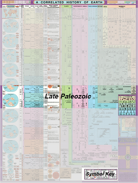
Answer Quiz Me! questions B05 through B12 using the A Correlated History of Earth poster (see the PDF link below). Refer to the Late Paleozoic (Mississippian through Permian) section to answer the questions.
|
A Correlated History of Earth |
|
See the symbol key for definitions of the many map symbols and features. |
Time, Tectonics, Volcanics, & Classic Rock Units

Life Forms
Late Paleozoic Paleogeography
The Late Paleozoic across Euramerica included significant tectonic activity on both east and west margins. In the east, mountain-building continued where there had once been a broad passive continental margin. Compressional tectonics occurred in the west as well. "Island mountains" formed in the Colorado region as even the craton was deformed. Arizona was spared most of this deformation, and was the site of many different sedimentary depositional environments over time, from shallow cratonic seas to coastal deserts to flood plains.
|
|
|
|
Figure 11-6. Western Euramerica during the Late Paleozoic. At left, a warm, shallow, cratonic sea covered much of the craton during the Mississippian (Redwall time). At right, a large coastal sand desert occupied a portion of the western edge of Euramerica during the Permian (Coconino time). |
|


Let's return to the Paleogeography and Geologic History of the Southwestern U.S. page to learn more about Late Paleozoic paleogeography and answer Quiz Me! questions B13 through B18 (see the PDF link below). Refer only to the Mississippian, Pennsylvanian, and Permian text and maps in the Late Paleozoic section.
|
Paleogeography and Geologic History of the Southwestern U.S. |
|
Tan/brown represent land areas, light blue represent shallow marine areas, and dark blue represent deep marine areas. |
Mississippian
Pennsylvanian
Permian