Prelude
Around Arizona, you can see sedimentary rock layers stacked on top of each other like pages in a book. In fact, sedimentary rocks cover most of the Earth's surface, so you will likely encounter them on your travels. Sedimentary layers usually contain many clues about the geologic history of an area, and can tell us much about the geologic past. For instance, several rock units in the Grand Canyon contain fossilized remains of shallow marine organisms, meaning that long before the Colorado River cut the Grand Canyon, an ocean must have covered northern Arizona!
Sediment is formed by the mechanical and chemical weathering of rocks on Earth's continents. Biologically produced microscopic shell material is also a major source of sediment. Processes of flowing water, blowing wind, and moving ice distribute this debris across much of Earth's surface, including environments such as river flood plains, beaches, desert sand dunes, or the bottom of the ocean.
Compaction and cementation of sediment over time represents the process of lithification, and sedimentary rocks are born. Because sedimentary rocks were once sediments, they record the surface conditions of the past, like where they originated, how far they were transported, when and where they were deposited, etc. Sedimentary petrologists and stratigraphers are basically time travelers who use various clues in sediment and sedimentary rock to look back in time to gain an understanding of Earth's history. Arizona and the desert Southwest is a great place to study sedimentary rocks because of their abundant exposures in places like the Grand Canyon, Zion, Bryce, Canyonlands, Monument Valley, Canyon de Chelly, etc.
|
|
|
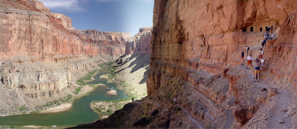
Figure 5-1. Paleozoic sedimentary rocks exposed along the Colorado River in the Grand Canyon. This view is to the south from the Nankoweap Granaries about 600-700 feet above the river. Remember to click on the highlighted images to see larger versions. |
What Will You Do Today?
|
|
Identify and interpret different types of sediment, sedimentary structures, and sedimentary rocks, as well as read geologic maps and stratigraphic columns that include sedimentary rocks |
A. Sediment & Sedimentary Structures - Identify and interpret different types of sediment and sedimentary structures
B. Identifying & Interpreting Sedimentary Rocks - Identify and interpret different kinds of sedimentary rock
C. Sedimentary Rocks in Geologic Maps - Read and interpret sedimentary units from the Geologic Map of Arizona and the Geologic Map of the Lees Ferry Area
D. Physical Stratigraphy - Learn the basics of how to interpret and correlate sedimentary units in stratigraphic columns