Part D
Relative Geologic Dating Principles & Sequence Diagrams
Have you ever looked at a landscape and wondered what must have happened to form such natural beauty? Many mountain sides, stream canyons, and road cuts contain exposures of rock units that tell a story of the geologic past. Even on the hand sample and microscopic level, rocks tell a story of their past. On the larger scale, these relations are typically represented on geologic maps and cross sections. Let's chat about some of the common sense observations and interpretations that you can make to determine the geologic history of an area.
|
|
|
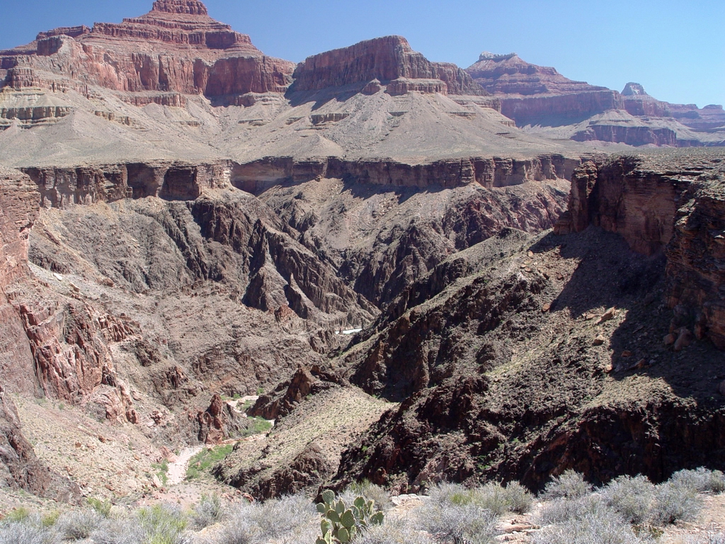
Figure 3-8. Geologic history is displayed in the rocks of the Monument Creek area of the Grand Canyon. |
Relative Dating Principles
To decipher the geologic history from a map or cross section, we must determine the age of rock units and geologic structures. Ages can be absolute, where a certain number represents the age of the rock (e.g., the age of volcanic rock at Tempe Butte is 17.6 Ma). Absolute ages are determined by a number of different methods that typically involve measurement of radioactive isotopes in certain minerals. Ages also can be relative, where the number age is not determined, only the relative order of ages (e.g., the Kaibab Formation is younger than the Hermit Formation). A few important relative dating principles are critical for interpreting geologic cross sections, including Superposition, Original Horizontality, Cross-cutting Relations, and Inclusions. Figures 3-9 through 3-13 show some of the most important relative age dating principles. Relative and absolute age dating can be used together to create an ordered history of geologic events that may or may not have precise number dates attached to it. Some of the most important relative age dating principles are reviewed below.
Superposition
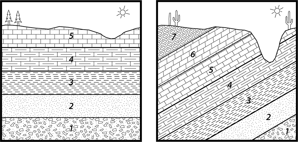
Sedimentary and volcanic layers are originally deposited at the surface on top of one another, so that the rocks on the bottom of a sequence are always the older than those at the top of the sequence (see Figure 3-9). This also applies to tilted layers as long as the sequence has not been overturned.
Original Horizontality
Sedimentary and volcanic units are also typically deposited on the Earth's surface in horizontal or nearly horizontal layers. Thus, if these rocks are tilted or dipping, then the layers must have been disturbed by fault rotation or folding sometime after the rocks were deposited (see Figure 3-9).
|
|
|
Figure 3-9. Cross sections showing the relative dating principles of Superposition (left) and Original Horizontality (right). Units and structures with lower numbers are older than units with higher numbers. The fill patterns represent specific rock types. |
|
|
|
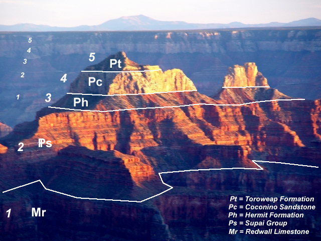
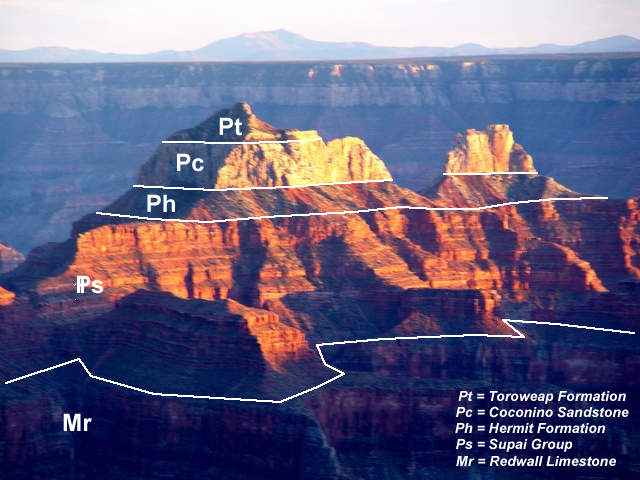
Figure 3-10. Field relations showing the relative dating principle of Superposition and Original Horizontality in the Grand Canyon. View is to the south from the North Rim across Bright Angel Canyon of Brahma Temple (left) and Zoroaster Temple (right). The light-colored cliffs are mostly Coconino Sandstone, whereas the reddish rocks below belong to the Hermit Shale and Supai Groups. Kendrick Mountain is on the skyline. Click on the picture to see the annotated image. |
|
Example 8 |
|
|
|
Which of the labeled sedimentary units is the youngest? |
|
Pt (Toroweap Formation) The Toroweap Formation overlies the others, and the Principle of Superposition says that younger sedimentary layers overlie older sedimentary layers. |
Cross Cutting Relations
Where a fault cuts across other rock layers, the fault is younger than the layers it cuts. Additionally, where an igneous intrusion cuts across or bakes other rock units, the intrusion is younger than the units it cuts across or bakes. In other words, the older rocks need to exist before they can be faulted, intruded, or baked (see Figure 3-11 and 3-12).
|
|
|
Figure 3-11. A cross section displaying the relative dating principles of cross-cutting relations and inclusions. Units and structures with lower numbers are older than units with higher numbers. |
|
|
|
|
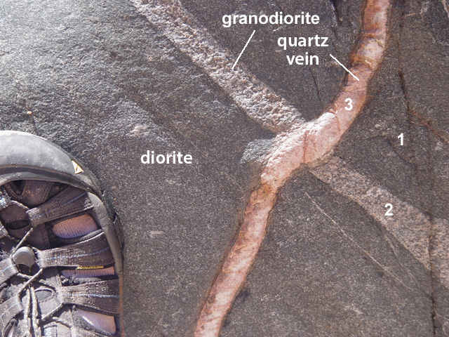
Figure 3-12. Field relations showing the relative dating principle of cross-cutting relations in Tuna Creek, Colorado River mile 99.1, Grand Canyon. On the left, the light-colored granite intrusion is offset by a small fault. The fault that must have occurred after the granite intrusion had cooled enough to respond to the stress by breaking (brittle deformation) instead of folding (ductile deformation). On the right, two light-colored intrusions crosscut the darker diorite host rock. Click on the pictures to see the annotated images. |
|

|
Example 9 |
|
True or False: the fault is younger than the light-colored volcanic tuff. |
|
True |
Inclusions
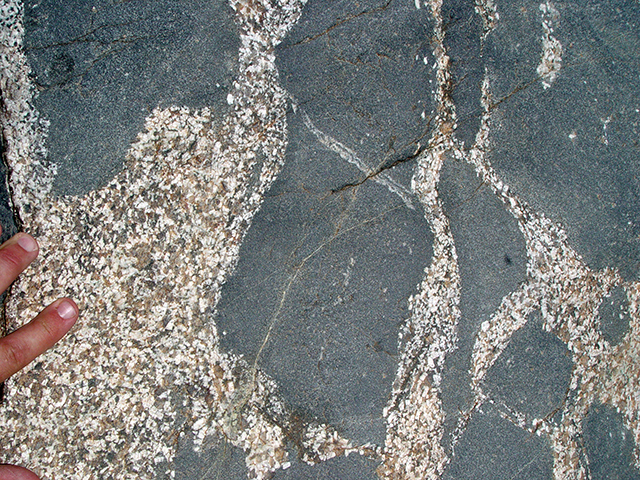
A rock that contains inclusions (pieces of another rock) is younger than its inclusions. In other words, the inclusions must have formed first in order for them to be included within the host rock (i.e., the inclusions are older than their host rock). Igneous intrusions may contain pieces of wall rock that become inclusions in the magma (see Figure 3-13). When the inclusions are a different rock than the host, they are called xenoliths ("foreign rock"). Some sedimentary rocks (like conglomerate and breccia) also contain pieces or pre-existing rock (see Figure 3-14). These pieces are called clasts.
|
|
|
Figure 3-13. Field relations showing the relative dating principle of inclusions in Tuna Creek, Colorado River mile 99.1, Grand Canyon. The darker amphibolite inclusions (xenoliths) are surrounded and intruded by lighter granodiorite, thus the amphibolite is older than the granodiorite. The angularity of the xenoliths suggest short exposure time to the host magma. Rounded xenoliths typically represent higher degrees of thermal-mechanical erosion from longer exposure to assimilation processes. Swiss army knife for scale. Click on the picture to see the annotated image. |

|
|
|
Figure 3-14. Field relations showing the relative dating principle of inclusions in Titus Canyon, Death Valley NP. The darker limestone inclusions are surrounded by a calcite-rich matrix, thus the limestone blocks are older than the sedimentary mega-breccia unit that contains them. The big limestone clast at left is about 2 meters wide. Click on the picture to see the annotated image. |

|
Example 10 |
|
Which is older, the light-colored granite or the dark-colored amphibolite? |
|
The amphibolite The ampibolite forms inclusions are within the granite host rock, and the Principle of Inclusions says that the inclusions are older than the host rock. |
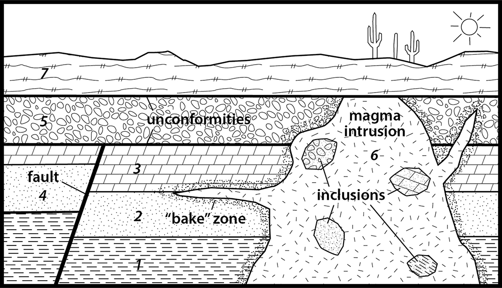
Geologic Sequence Diagrams
A geologic sequence diagram is basically a geologic cross section where the relative order of units/events has been determined using the common sense relative dating principles described above. We can now apply the various relative dating principles to a geologic cross section and begin to describe the geologic history of an area. In doing this, a geologist commonly starts with the oldest possible unit and works forward in time.They ultimately must determine the order of events that formed the units and structures in the cross sectio n. While the geology shown in these diagrams may not be visible in a single location, but is a compilation meant to summarize the geology of an area.
|
|
|
Figure 3-15. A geologic cross section is referred to as a sequence diagram when used to illustrate the order of geologic events. Unit R is an igneous intrusion with inclusions and a "bake zone". |
|
Example 11 |
|
|
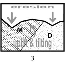
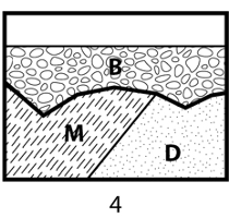
What is the most probable sequence of events created this geologic cross section that we see today? |
|
|
|
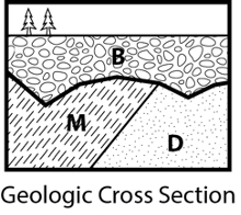
Using Superposition and Original Horizontality, we determine that sandstone unit D was deposited first (1). |
|
|
This was followed by deposition of mudstone unit M (2). |
|
|
A period of uplift, tilting, and erosion must have followed (3). |
|
|
Conglomerate unit B was then deposited last (4). |
|
We now have established an order of events (a geologic history) for this cross section, making it a geologic sequence diagram. In a geologic history sequence, we list the rock units from left to right with the oldest units on the left. D - M - B The period of uplift and erosion between M and B is implied, but not listed in the sequence. |
|
|
Example 12 |
|
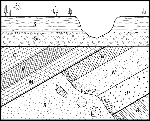
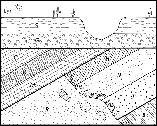
Use relative dating principles to determine the proper age sequence of the rock units (from oldest to youngest). |
|
B - T - N - H - R - M - K - C - G - S |
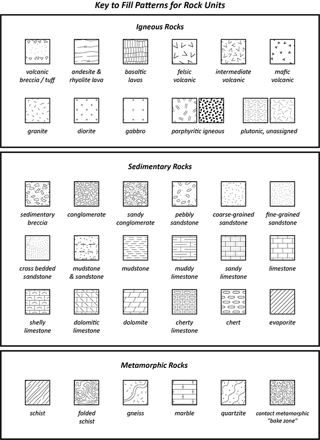
Units in sequence diagrams, geologic cross sections, and geologic maps can be given pattern fills that represent a certain rock type. A key showing the fill patterns used for diagrams in this class is shown in Figure 3-16. With knowledge of the rock types from the fill patterns, further interpretations can be made about the geologic history.
|
|
|
Figure 3-16. Fill patterns for map units. Click HERE for a printable PDF version. * IMPORTANT * |
|
Example 13 |
|
What type of rock does this fill pattern represent? |
|
Limestone (a sedimentary rock) |


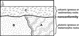
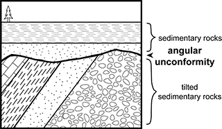
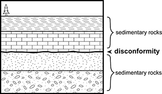
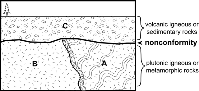
Unconformities
Unconformities are contacts between adjacent rock units that are significantly different in age. Understanding how to recognize and interpret these features is important in unraveling the geologic history of an area. There are three distinct types of unconformities that are defined by the type of rock ABOVE and BELOW the unconformity and/or their ORIENTATION: nonconformities, angular unconformities, and disconformities.
|
Nonconformity |
|
|
Plutonic or metamorphic below the unconformity; sedimentary or volcanic rocks above. |
|
|
Look for igneous or metamorphic rock types; know their fill patterns in the sequence diagrams. |
|
Angular Unconformity |
|
|
The layered rocks above and below the unconformity are at an angle to each other. |
|
|
Look for two sets of sedimentary layering with an angular difference in orientation. |
|
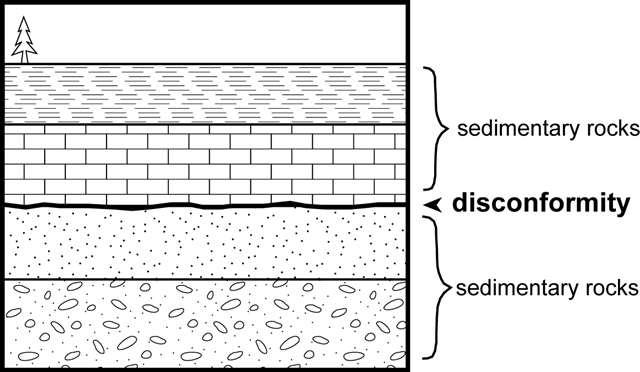
Disconformity |
|
|
The layered sedimentary rocks above and below the unconformity are parallel to each other. |
|
|
Look for all sedimentary layering that all has the same orientation. |
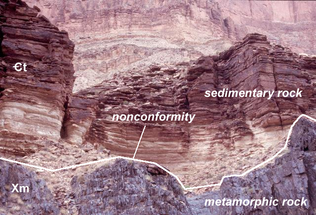
Nonconformities
A nonconformity is a contact between rocks that form at the Earth's surface and rocks that formed at depth within the Earth (see Figures 3-17 and 3-18). Older metamorphic and plutonic igneous rocks (units A and B) can be exposed at the surface due to tectonic uplift (possibly with tilting) and erosion. Subsequent deposition of sedimentary or volcanic rocks (unit C) directly on top of the older rocks (units A and B) produces the nonconformity, which represents the period of uplift, tilting and erosion. The age difference between unit C and units A & B below may be significant (millions or billions of years) and represents a maximum time it takes for uplift, erosion, and deposition to occur.
|
|
|
Figure 3-17. A geologic cross section showing a nonconformity. |
|
|
|
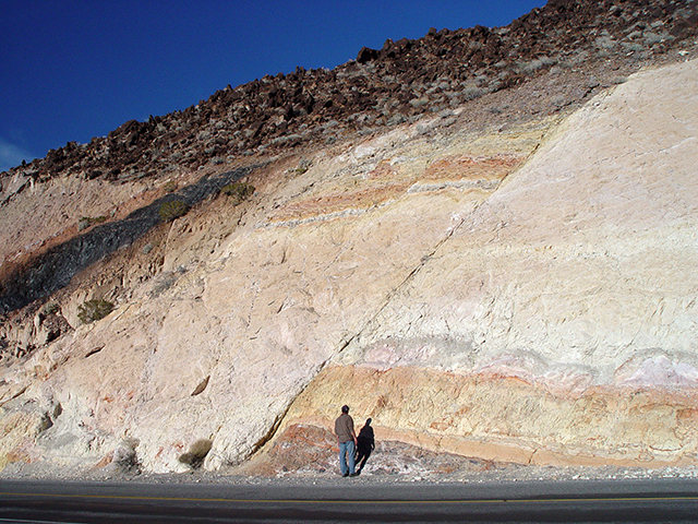
Figure 3-18. A nonconformity at Colorado River river mile 119.5 in the Grand Canyon (near Blacktail Canyon). The layered sedimentary rocks of the Cambrian Tapeats Sandstone overlie the purplish-gray Paleoproterozoic metamorphic rocks of the Brahma Schist to form this nonconformity, also known as "the Great Unconformity". The unconformity here spans the period between 1750 Ma and 520 Ma - that's 1230 million years! Click on the picture to see the annotated image. |
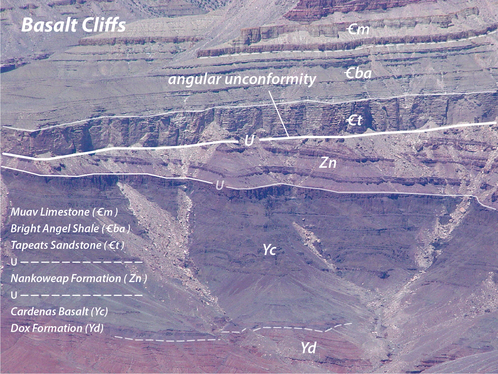
Angular Unconformities
An angular unconformity is relatively easy to recognize because it is a contact between rocks layers that are at an angle to each other (see Figures 3-19 and 3-20). It consists of tilted or folded sedimentary rocks that are overlain by younger layers. Angular unconformities suggest that uplift, tilting, folding, and erosion occurred between the time of deposition of the layers above and below the contact. The tilting and folding likely represents a deformational (mountain-building) event.
|
|
|
Figure 3-19. A geologic cross section showing an angular unconformity. |

|
|
|
Figure 3-20. Field relations showing an angular unconformity in the Grand Canyon. View is to the north from Desert View of the Basalt Cliffs angular unconformity formed by relatively flat-lying Cambrian sedimentary rocks and the gently tilted Proterozoic rocks. Click on the picture to see the annotated image. |
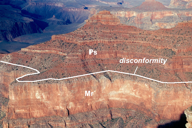
Disconformities
A disconformity is a contact between parallel (but not necessarily horizontal) sedimentary layers that are significantly different in age (see Figures 3-21 and 3-22). Rocks above and below a disconformity may look similar, so it may be difficult to identify without any additional information. Helpful observations that suggest significant time difference between the two units include the presence of lower unit inclusions in the upper unit, large differences in the abundance and types of fossils across the contact, stream channels carved into the lower unit, etc. Disconformities suggest a period of erosion occurred with little or no tilting or folding.
|
|
|
Figure 3-21. A geologic cross section showing a disconformity. |
|
|
|
Figure 3-22. Field relations showing a disconformity in the Grand Canyon. View is to the northeast from Yavapai Point toward O'Neill Butte. Click on the picture to see the annotated image. |
Putting It All Together
Let's finish by using some of the relative dating concepts to understand the geology Lava Canyon.
|
|
|
Figure 3-23. The Lava Canyon geologic sequence diagram. Click HERE for a printable PDF version of this sequence diagram. |
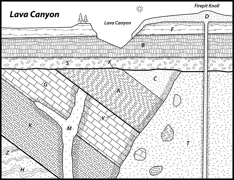
Answer Quiz Me! questions D45 through D50 using the Lava Canyon sequence diagram (Figure 3-23). If necessary, you can print a hard-copy of the diagram (see the link above). Also refer to the Key to Map Fill Patterns (click HERE for a printable PDF version).
After finishing this lesson, complete the form below: