Part C
Tectonic Plates & Their Movement
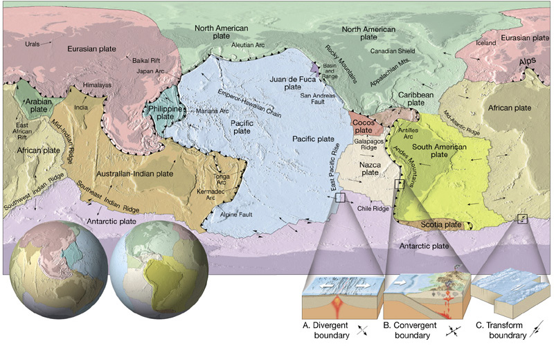
The lithosphere is divided into several major plates and many minor plates (see Figure 10-5). These lithospheric plates move slowly (about 10 cm/yr or less) on top of the asthenosphere and interact with each other along their margins. There are several types of plate boundaries, including convergent (collisional), divergent (extensional or spreading), and transform. Geologic processes can also occur within plates, at intraplate tectonic settings.
|
|
|
Figure 10-5. The major tectonic plate of the world and the types of plate boundaries. |
Tectonic Plates & Plate Boundaries
Many types of geologic processes are active at tectonic plate boundaries, like earthquakes, volcanism, and mountain-building. The types of plates present at each boundary largely determines what type of geologic activity occurs there. Various plate tectonic settings are illustrated in Figures 10-6 through 10-9.
|
|
|
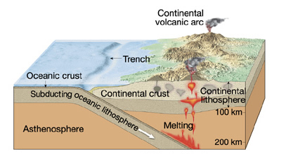
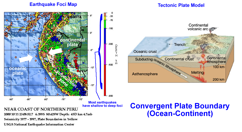
a) An ocean-continent convergent boundary has an oceanic lithospheric plate subducting beneath continental lithospheric plate. Shallow- to deep-focus earthquakes occur in the subducting oceanic plate and a continental volcanic arc develops in the overriding continental plate. |
|
|
|
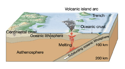
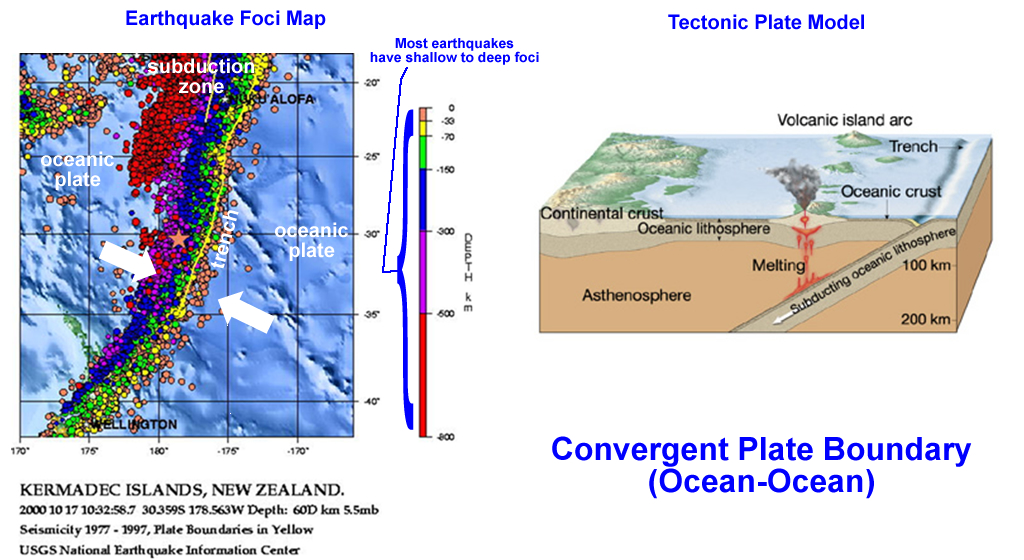
b) An ocean-ocean convergent boundary has an oceanic lithospheric plate subducting beneath another oceanic lithospheric plate. Shallow- to deep-focus earthquakes occur in the subducting oceanic plate and an island arc develops in the overriding oceanic plate. |
|
|
|
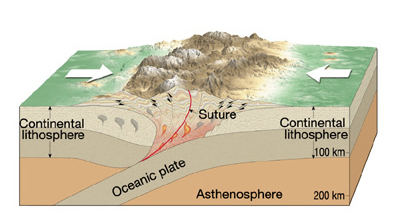
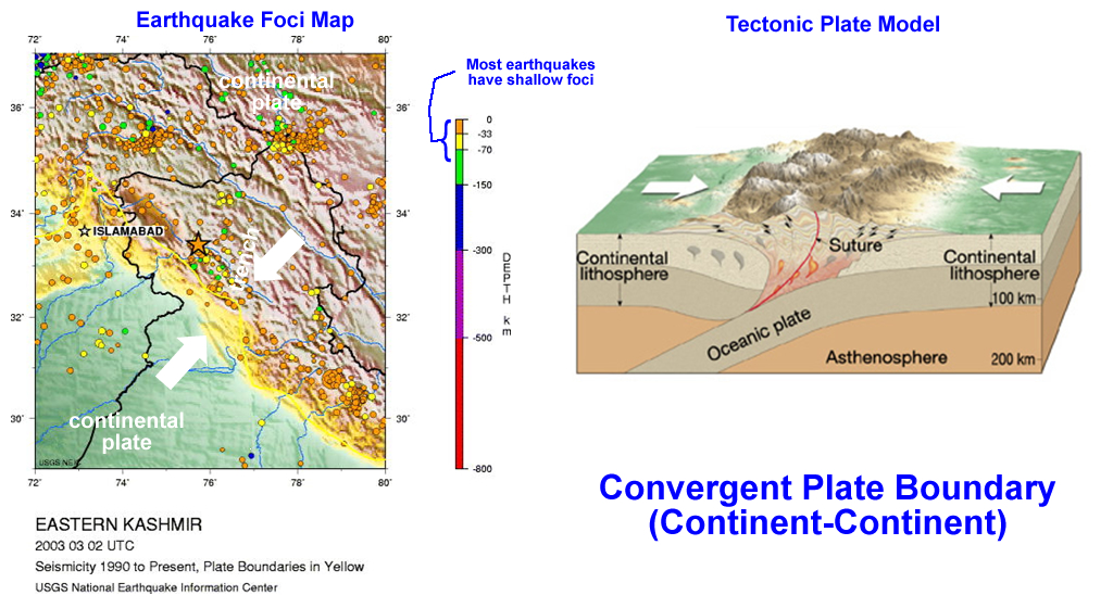
c) A continent-continent convergent boundary has two colliding continental lithospheric plates. Large tectonic mountain belts can form in this setting, but with no subduction, shallow-focus earthquakes dominate and little if any volcanism occurs. |
|
Figure 10-6. Convergent tectonic plate boundaries. |
|
|
|
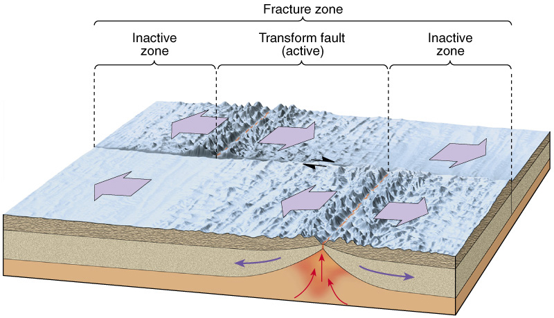
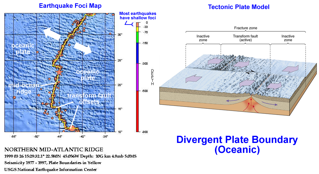
a) An oceanic divergent boundary (or spreading center) has two oceanic lithospheric plate moving away from each other in opposite directions. A mid-ocean ridge mountain belt forms due to thermal uplift, and much basaltic volcanism occurs along the ridge axis. With no subduction, shallow-focus earthquakes dominate. Mid-ocean ridges are commonly offset by oceanic transform faults. |
|
|
|
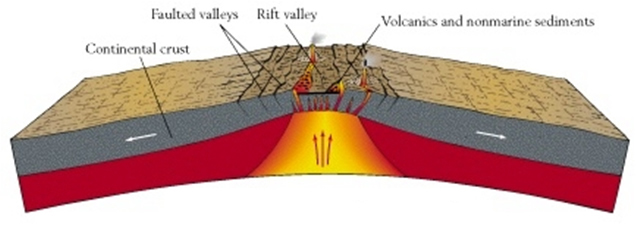
b) A continental divergent boundary (or continental rift) forms as continental lithosphere extends and thins. With no subduction, shallow-focus earthquakes dominate. |
|
Figure 10-7. Divergent tectonic plate boundaries, including oceanic transform boundaries. |
|
|
|
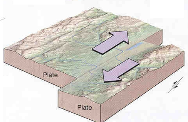
Figure 10-8. Continental transform tectonic plate boundaries. These plate boundaries have two continental lithospheric plate moving past each other in opposite directions. With no subduction, shallow-focus earthquakes dominate and little or no volcanism occurs. |
|
|
|
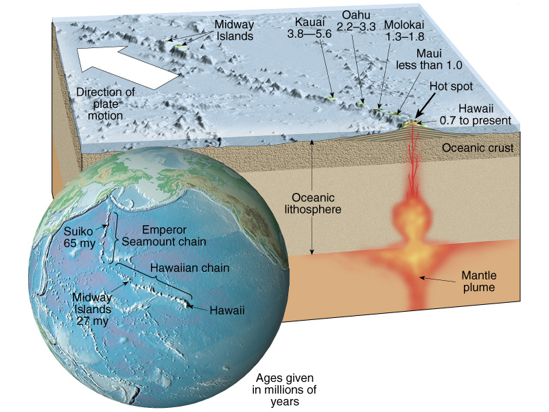
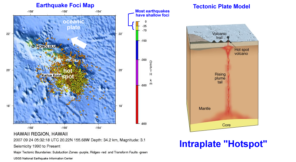
Figure 10-9. Intraplate "hot spots". |
|
This is not a tectonic plate boundary, but instead, it is a volcanic feature that forms within a plate (either oceanic or continental). Hawaii is an oceanic hotspot, whereas Yellostone is a continental one. The hot spot is the point on the surface of the moving lithosphereic plate that is overriding a stationary mantle plume. Volcanic chains are formed as the plate carries older volcanoes away from the hot spot. Oceanic hot spots typically build large shield-type volcanic island chains (e.g., the Hawaiian Islands) that eventually become seamounts as they sink beneath sea level (e.g., the Emperor Seamount chain). |
Earthquake Foci Maps
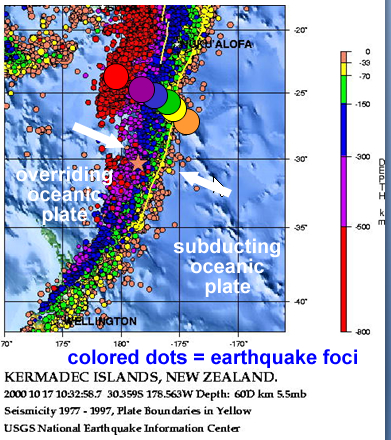
Seismic data collected over the past few decades have been used to create maps showing the distribution and depth of earthquakes around the world. These maps show the location of earthquake foci (the point within the Earth where the release of seismic energy originates) with different colors that represent different depths (see Figure 10-10). Figures 10-11 through 10-15 show the earthquake foci maps for some of the major plate tectonic settings.
|
|
|
|
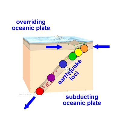
Figure 10-10. Earthquake foci (hypocenters) data and interpretation. Maps of earthquake foci (left) show the depth and distribution of earthquakes and can be used to represent the three-dimensional geometry of interacting plates (right). |
|
|
|
|
Figure 10-11. Oceanic divergent boundary earthquake foci map and tectonic plate model. |
|
|
|
Figure 10-12. Ocean-Ocean convergent boundary earthquake foci map and tectonic plate model. |
|
|
|
Figure 10-13. Ocean-Continent convergent boundary earthquake foci map and tectonic plate model. |
|
|
|
Figure 10-14. Continent-Continent convergent boundary earthquake foci map and tectonic plate model. |
|
|
|
Figure 10-15. Oceanic intraplate "hot spot" earthquake foci map and tectonic plate model. |
Refer to the earthquake foci maps and tectonic plate models in Figures 10-11 through 10-15 to answer Quiz Me! questions C21 to C24.
The Earth's Fractured Surface
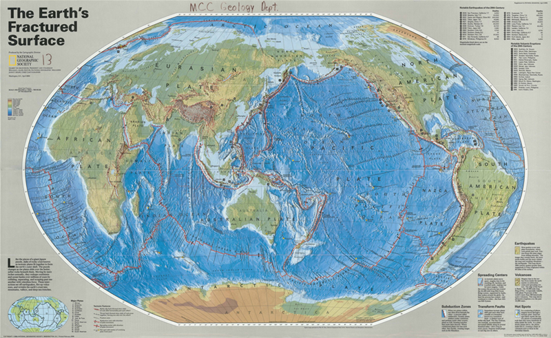
The Earth's Fractured Surface, a map published by National Geographic, shows many of the Earth's tectonic plates, as well as hot spots, earthquakes, volcanism, etc.
|
|
|
Figure 10-16. The Earth's Fractured Surface map. |
Answer Quiz Me! questions C25 through C40 using The Earth's Fractured Surface map (see the PDF link below).
|
The Earth's Fractured Surface |
Map Scale
Map
Notice that any single tectonic plate may include both continental lithosphere and oceanic lithosphere. For example, the eastern part of the North American plate includes oceanic lithosphere (dark blue), whereas the western part has continental lithosphere (light blue, brown, and green).